
Doe een donatie
Rust jezelf uit voor je volgende avontuur:
Als Amazon-partner verdient deze site een commissie op in aanmerking komende aankopen, zonder extra kosten voor jou.
Topografische kaart Ankara
Klik op de kaart om de hoogte weer te geven.
Doe een donatie
Rust jezelf uit voor je volgende avontuur:
Als Amazon-partner verdient deze site een commissie op in aanmerking komende aankopen, zonder extra kosten voor jou.
Ankara
Ankara heeft een uitgebreid metronetwerk. Ankara huisvest vele universiteiten alsook de Turkse militaire academie. De stad ligt op een gemiddelde hoogte van 938 meter boven zeeniveau.
Doe een donatie
Rust jezelf uit voor je volgende avontuur:
Als Amazon-partner verdient deze site een commissie op in aanmerking komende aankopen, zonder extra kosten voor jou.
Over deze kaart
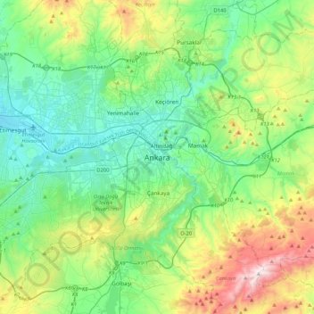
Naam: Topografische kaart Ankara, hoogte, reliëf.
Locatie: Ankara, Çankaya, Ankara, Centraal-Anatolië, 06420, Turkije (39.76078 32.69405 40.08078 33.01405)
Gemiddelde hoogte: 1.082 m
Minimale hoogte: 798 m
Maximale hoogte: 1.864 m
Doe een donatie
Rust jezelf uit voor je volgende avontuur:
Als Amazon-partner verdient deze site een commissie op in aanmerking komende aankopen, zonder extra kosten voor jou.