
Topografische kaart Zernez
Interactieve kaart
Klik op de kaart om de hoogte weer te geven.
Zernez
Het dorp Zernez ligt aan de Inn (En) op een hoogte van 1473 meter, bij de monding van de Spöl. Via het Val dal Spöl loopt vanuit Zernez een weg die over de Ofenpas (Pass dal Fuorn, 2149 meter) naar het Münsterdal (Val Mustair) voert. Het dorp heeft een station aan de Rhätische Bahn en is door zijn centrale ligging een populaire uitvalsbasis voor toeristen.
Over deze kaart
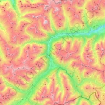
Naam: Topografische kaart Zernez, hoogte, reliëf.
Gemiddelde hoogte: 2.297 m
Minimale hoogte: 1.199 m
Maximale hoogte: 3.366 m
Andere topografische kaarten
Klik op een kaart om zijn topografie, zijn hoogte en zijn reliëf te bekijken.
Val Sinestra
Zwitserland > Graubünden > Region Engiadina Bassa/Val Müstair > Valsot
Gemiddelde hoogte: 2.199 m
Martina
Zwitserland > Graubünden > Region Engiadina Bassa/Val Müstair > Valsot
Gemiddelde hoogte: 1.494 m
Tschierv
Zwitserland > Graubünden > Region Engiadina Bassa/Val Müstair > Val Müstair > Tschierv
Gemiddelde hoogte: 2.023 m