
Topografische kaart Sarnen
Interactieve kaart
Klik op de kaart om de hoogte weer te geven.
Sarnen
De stad ligt op een hoogte van 473 meter, omvat 7688 hectare (76.88 km², waarvan 376 hectare meer en heeft 9353 inwoners (2004). Het ligt aan het uiteinde van het Meer van Sarnen (Sarnersee). Tot de gemeente Sarnen horen ook de dorpen; Wilen, Stalden ob Sarnen, Ramersberg en Kägiswil.
Over deze kaart
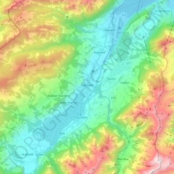
Naam: Topografische kaart Sarnen, hoogte, reliëf.
Locatie: Sarnen, Obwalden, Zwitserland (46.85422 8.06700 46.93346 8.27766)
Gemiddelde hoogte: 1.040 m
Minimale hoogte: 428 m
Maximale hoogte: 2.354 m
Andere topografische kaarten
Klik op een kaart om zijn topografie, zijn hoogte en zijn reliëf te bekijken.